Docklands and the Thames,
Victoria Park to Paternoster
Square. Take a nostalgic
trip back to the East End in
the 1950’s or a stroll around
the Square Mile of the City
of London. It’s all here at
barryoneoff.co.uk
Copyright 2002 - 2024 ©Barry Carter. All rights reserved
LONDINIUM the founding of a city
The Roman beginnings
It began to take shape over two thousand years ago when the Emperor Claudius came with his army to conquer Britain and turn a patch of grassy marshland dominated by two hills into a fortified city on the banks of the River Thames. A few centuries later it would be a thriving commercial settlement surrounded by great stone walls and ditches with large city gates being the only access. This Roman city covered an area of approximately one square mile. The City itself is still referred to today as "The Square Mile" even though the rest of the capital has spread out many miles beyond. Because this section of London’s history is so far behind us it is easy to forget the influence that the Romans had on the City and indeed we may wonder if London would exist at all. They occupied us for more than four hundred years, around a fifth of our history to date! If they were leaving now (2022), it would mean that the invasion would have taken place just after Elizabeth I ended the Tudors reign. They were here all those years. That gives an idea of the time scale.From Kent to Colchester
The Roman army under the leadership of Aulus Plautius landed in Kent. They successfully battled the Britons by the banks of the Medway and began chasing them as they retreated towards the Thames. The local inhabitants had the advantage here, as they knew the sand banks and fords of the then wider and shallower river. They were able to cross to the north side on foot and horseback. This gained them some time as they headed towards Essex. The Invaders had to use German prisoners, now mercenaries of the Roman army, to swim the Thames while the rest built a pontoon bridge. Claudius himself then arrived with reinforcements including a herd of Elephants. They pursued the Britons to the then capital, Colchester (Catuvellauni). From there the Roman victors planned their takeover of the rest of Britain. One thing the Romans were unrivalled at was the construction of roads, and the one between Londinium and Colchester was an important addition.Claudius not Julius
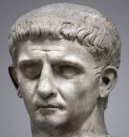
Contrary to popular belief it was not Julius Caesar who led Roman troops to conquer Britain, but Claudius. Julius visited in 55 BC and again in 54 BC. He had a few skirmishes but had no intention to conquer. He did not want Britain. He was already too involved with taking Gaul. The trip to Britain was to cut off supplies. It was almost a century later in 43 AD that the conquering army arrived. Claudius, a cripple with a stutter, needed to prove to his people that he was worthy of the role of Emperor. He needed a triumph and Britain seemed the ideal solution. It is debatable where the name Londinium came from but the majority opinion now is that it was the Romans, as there is no evidence that a permanent settlement existed before they came. One piece of evidence (or lack of) are Julius Caesar's notes. There are none! Caesar was meticulous about recording his exploits but made no mention of any settlement here after visiting twice. An organized community would have been important enough to mention. I read a theory some time ago, by Richard Coates, suggesting the name came from the pre-Celtic European word 'Plowonida', meaning ‘from two roots’, plew and nejd, meaning something like "the flowing river" or "the wide flowing river". Londinium therefore means "the settlement on the wide river". He suggests that the river was called the Thames upriver where it was narrower, and Plowonida down river where it was too wide to ford. Other suggestions have been made in the past. One example is that the name derives from the mythical King Lud.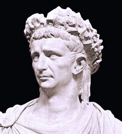
Building the fort
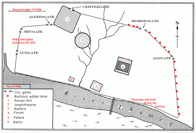
The boundary of the City of London has a step at it’s Northwest corner. This is because the Fortress was built before the walls were planned and the stone structure was square. The City walls were added at a later date and the fort left in place to form a part of them. The fort was constructed around the year AD 120 and the walls were started roughly 80 years later. The material used to build the walls was Kentish rag-stone. 85,000 tons of it transported down the river Medway and round the coast into the Thames. The remains of a Roman sailing barge were found in the Thames in 1962. It seems it was wrecked close to the mouth of the Fleet River near where the present Blackfriars Bridge stands. Some of it's cargo of rag-stone was still on board. It’s generally believed that the fort was built as barracks rather than defensive purposes. When the fort was built Roman forces had become a large part of the population. It is estimated that it housed around 1,000 men. The fort walls were about four feet thick and fifteen feet tall with rounded bastions on the corners. The Northern entrance to the fort was later to become Cripplegate and the Western gate would eventually be bricked up and replaced by Aldersgate. You can still see the remains of medieval bastions that were built on top of the Roman ones which were gradually covered during the centuries the city was deserted when the Romans left in 410 AD. These are known as the Dark Ages.Building the walls
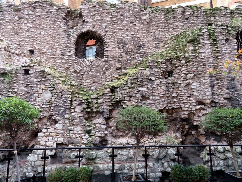
The building of the City walls began circa 190 AD and the fort was merged with them. The new walls were about 9 feet thick, twice the thickness of the fort walls, and around twenty feet high. The Kentish rag stone was tied with a layer of terra-cotta tiles every metre or so to bond the wall. A ditch was dug around the wall and the removed earth used to shore up on the inside. This wall stretched around the settlement with six gates giving access. The seventh gate (Moorgate) was added in the medieval period. In the third century the river wall was added. In the fourth century twenty bastions were added to the East wall. The reason why is not clear but they seem to have been in a hurry, as tombstones and other items were included in the building materials.Discovering the Roman
Amphitheatre
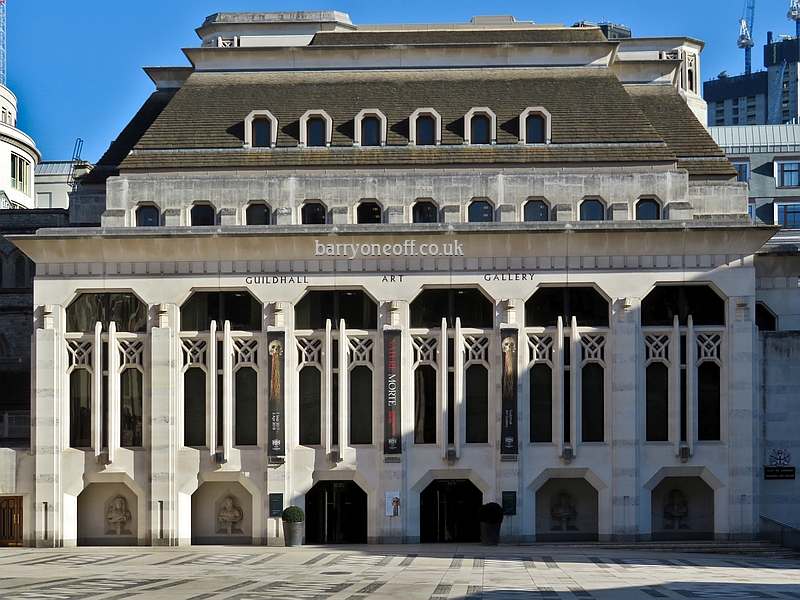
The Roman Amphitheatre was known to exist but nobody knew where it was until accidentally discovered. In 1988 during excavation work for the building of the new Guildhall Art Gallery it was found under Guildhall Yard. Work was halted for a few years delaying the opening of the new gallery. Most of it remains buried under Guildhall Yard but a section underneath the gallery was turned into an exhibition. A slate circle in the yard shows the circumference of the amphitheatre.Where to build a city
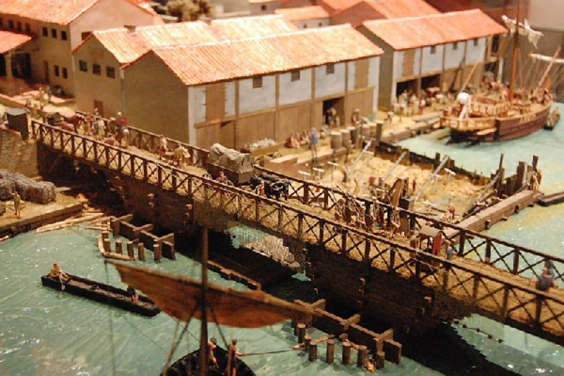
They looked at the three main rivers - The Thames, Severn, and Trent when deciding where to build the City. The Thames was chosen because of its tidal habits as well as it’s relative closeness to Europe. Both trade and threat of invasion were major factors in the making of the final decision. The fresh water supplies were also taken into consideration and in those days there were fresh clear rivers, streams and springs all over the city site. The layout of the land consisted of two hills set in lush green marshland and a wide shallow river with sand banks at low tide. The river was much wider and shallower than it is today. At the point where the present London Bridge stands the width then, was five times as wide. Well over half a mile. Man has extended the banks as time passed. Approximately 100 metres on the City side of the river has been reclaimed. It is believed that the first fording of the river could have been at Westminster or Vauxhall. Once the site had been decided upon they picked the lowest possible crossing point of the river at the time. That is why London now stands in its present position. They needed it narrow enough to cross, but at the same time be as close to the estuary as possible.The first settlement
destroyed
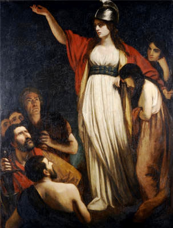
The site consisted of two large hills with the Walbrook river and it’s tributaries between them and the Fleet to the West. There were woodlands and marshes around the hills. These were to become today’s Pool of London and the hills are now Ludgate and Cornhill. The Roman city would have been around twenty feet below the level of today’s City streets. The first trading settlement had been established on the East side of the Walbrook around 50 AD. but this was to last only a decade. In 60 AD Boudica and the Iceni tribe were in revolt. The Romans had behaved badly towards her when her husband, a king, had died. They reneged on an agreement about his lands and raped her daughters. Boadicea and her followers went on the rampage, attacking the the Roman settlements. The bulk of the army was in Anglesey putting down a Druid revolt when the Iceni were heading for London but the Governor, Suetonius Paulinus, managed to return with a small force in time to evacuate those who wanted to leave. The people who chose to stay were massacred by Boadicea, and the settlement completely burned. The fire was so severe that it left a thick layer of burnt clay that was found during excavation work around Lombard and Gracechurch Streets and underneath No.1 Poultry.Rebuilding the City
After the revolt was put down and Boadicea killed (near the Midlands many believe) Julius Alpinus Classicianus was made the procurator, or civil governor. He kept the peace by not taking revenge on the local population. His tombstone incidentally would be used almost 400 years later as part of one of the hastily built bastions along the wall near the Tower of London, and was discovered in 1852. The settlement started to take shape again and the first Basilica and Forum was built in around 70 AD. The second, the largest of any north of the Alps replaced it in around 100 AD. The Romans liked their baths, and the bath houses found in Lower Thames Street (at Huggin Hill) and Cheapside are thought to have been built between 70 and 90 AD. The Governor’s Palace lies under Cannon Street Station and covered approximately 3 acres. It dates from about 80 to 100 AD. Early in the second century the fort was started followed by the City walls nearly a century later.