

Docklands and the Thames,
Victoria Park to Paternoster
Square. Take a nostalgic
trip back to the East End in
the 1950’s or a stroll around
the Square Mile of the City
of London. It’s all here at
barryoneoff.co.uk
Copyright 2002 - 2024 ©Barry Carter. All rights reserved
DOCKLANDS - The Isle of Dogs
The Isle of Dogs
The Isle of Dogs, strictly speaking, is not an island at all. It is the land contained in the horseshoe shaped bend in the river Thames. This bend forms a peninsula surrounded by water on the East, West and South sides. It was originally sparsely populated marshland before its drainage and planting in the 13th. century. In 1488 it was once again back to it's original marshy condition due to massive flooding. In the 17th. century the Dutch remedied this. One road led across the Marshes to an ancient ferry, at Ferry Road. There was rich grazing on the marsh, and cattle were killed for market in fields known as the Killing Fields, south of Poplar High Street. The western side of the peninsula was known as Marsh Wall, the district became known as Millwall with the building of the docks, and from the number of windmills constructed along the top of the flood defence.The Origin of The Name
Stebun heath, or Stepney Marsh, was the original name. There are two main theories about how it became known as the Isle of Dogs. The first is that King Henry VIII kept his dogs on the island and brought them to his palace at Greenwich by boat if he needed them for hunting. Apparently, there was a map from 1588 that reputedly refers to the area as the Isle of Dogs. The second theory is that when the Dutch engineers drained the marshes in the 17th century and claimed back the land lost to the 1488 flood, it became known as the Isle of Dykes. Over the years this gradually became corrupted to today's name. There was a flood defence wall in the mid 1600’s and the millers erected windmills on top of the wall to grind their corn, hence Millwall.Declaration of
Independence 1970
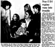
While writing this page, quite a few years ago, I found a few articles on the web stating that in 1920 the Isle of Dogs once declared independence. They gave no further details and I could find nothing to back this up. It seemed they had all found the first misprint and copied and pasted it without checking the facts. Instead of inserting an unverified statement as the others had done I decided to actually research the matter and managed to find out the following: The date the revolution actually took place was March 1st. 1970 not 1920. Labour councillor Ted Johns declared UDI (Unilateral Declaration of Independence) for the Isle of Dogs because of unsatisfactory amenities for the 10,000 residents. The two swing bridges that gave the only access to the island were blocked by the inhabitants. 37 year old Johns said, "We have declared UDI and intend to set up our own council" and "We can govern ourselves much better than they seem to be doing," he declared. "They have let the island go to the dogs." The "Island Council" was set up consisting of 30 members. Ted Johns was elected president. Two dockers and Lightermen were chosen as Prime Ministers. The only name I have been able to trace for one of these is John Westfallen. They announced that they would withhold rates meant for the Greater London Council and the London Borough of Tower Hamlets, and spend them locally. The newly born “Republic” had it's headquarters in Ted Johns council flat in Skeggs House, Manchester Road. On March 10th. The short lived regime began to crumble as people thought it had now gone too far and it gradually waned away. I'm glad I took the trouble to find out about this escapade, and wonder if it would work today. Power to the people; as Citizen Smith would have said! Ted Johns died on March 7th 2004 aged 71. R.I.P. More Docklands photos >>Building of the Docks
The West India Docks were the first to be opened in 1802. These were followed by the East India Docks, which were opened in 1806. The two were amalgamated in 1838. Millwall Docks were opened between 1864 and 1868. The two docks were kept separate until 1909 when the PLA (Port of London Authority) was formed. The PLA took them over and united them. These docks, situated as they were, going roughly from East to West, actually cut off the rest of the land and virtually made it a real island. The docks are still there today but are no longer used, apart from pleasure.The Fall and (High) Rise
of The Docks
The docks flourished and the population grew. Unfortunately the housing didn't grow as fast as the numbers of people. In 1851 there were 4,000 residents and already a housing shortage. By 1901 this figure had risen to 21,000. After the Second World War the docks became an important part of the economy and thrived for twenty five years, after which they went into rapid decline. They could not handle the new container shipments that took off in the mid sixties. The docks ran down to a virtual standstill by 1970 and were closed in 1980. People left the island and half of the 15,000 that stayed were unemployed. Today's Isle of Dogs is a success story. The whole area has been redeveloped from the last few years of the 20th. century until the present day and it is now one of the most popular places in London to live and work, with record high property prices. The Docklands Light Railway now gives easier access. Huge office blocks have been built, including the famous Canary Wharf Tower and many businesses have migrated there from the City of London. Apartments are sold for a fortune now, and the new residents prefer the area to be known as "Docklands" rather than the Isle of Dogs. The building work never seems to stop and is still going on at the time of this update in 2022


